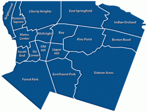
Our Neighbors
The City of Springfield is divided into many distinct neighborhoods, they are:
Bay – features Blunt Park.
Boston Road – features the Eastfield Mall. Primarily commercial in character, it features shopping plazas designed for automobile travel.
Brightwood – features numerous Baystate Health specialty buildings. Amputated from the rest of Springfield by the Interstate 91 elevated highway.
East Forest Park – features Cathedral High School. Borders East Longmeadow, Massachusetts.
East Springfield – features Smith & Wesson and the Performance Food Group.
Forest Park – features Forest Park and the Forest Park Heights Historic District, plus a commercial district at “The X”.
Indian Orchard – features a well-defined Main Street and historic mill buildings that have become artists’ spaces. Formerly a suburb of Springfield, Indian Orchard developed separately as a mill town on the Chicopee River before joining Springfield.
Liberty Heights – features Springfield’s three nationally ranked hospitals: Baystate Health, Mercy Medical, and Shriner’s Children’s Hospital. Liberty Heights includes eclectic districts like Hungry Hill and Atwater Park, and Springfield’s 3rd largest park, Van Horn Park.
Maple High – features Dr. Suess made famous Mulberry Street and the oldest cemetery in the City.
McKnight Historic District – features the largest array of historic, Victorian architecture, including over 900 Painted Ladies. McKnight was the United States’ first planned residential neighborhood. McKnight’s commercial district is called Mason Square. Features American International College.
Memorial Square – features the North End’s commercial district.
Metro Center – features nearly all major cultural venues in the region.[46] Commercial, cultural, civic, and increasingly residential in character. Features the Downtown Business District, The Club Quarter – with numerous festivals, cultural institutions, educational institutions, and significant historic sites.
North End – not technically a Springfield neighborhood, but rather three northern Springfield neighborhoods. Includes Brightwood, which is residential and medical in character, but cut off from the rest of the city by Interstate 91; Memorial Square, which is commercial in character; and Liberty Heights, which is medical and residential in character.
Old Hill – features Springfield College. Residential in character. Bordering Lake Massasoit.
Pine Point – features the headquarters of MassMutual, a Fortune 100 company. Primarily residential.
Six Corners – features Mulberry Street in the Ridgewood Historic District, the Lower Maple Historic District, and the Maple Hill Historic District. Urban and residential in character.
Sixteen Acres – features Western New England University and SABIS International School. Suburban in character. Includes much of Springfield’s post-World War II suburban architecture.
South End – features numerous Italian-American restaurants, festivals, and landmarks. Urban and commercial in character, this neighborhood was hard hit by the June 1, 2011 tornado. Includes the Naismith Memorial Basketball Hall of Fame; however, it is separated from it by Interstate 91.
Upper Hill – features Wesson Park. Bordering Lake Massasoit. Residential in character. Located between Springfield College and American International College.

